Severe storms with intense tornadoes expected to continue in Central US through Monday
Severe Storms with Intense Tornadoes Expected to Continue in Central US Through Monday
Severe storms with intense tornadoes expected – May has begun with a noticeable shift in weather patterns, as the central United States prepares for a significant storm event. After a subdued start to the month, atmospheric conditions are now favorable for an outbreak of severe thunderstorms, which are anticipated to persist through Tuesday. These storms will pose a heightened risk of powerful tornadoes rated EF3 or higher, alongside destructive hail, damaging winds, and heavy rainfall. The Central Plains and Midwest, known for their springtime volatility, may experience particularly strong storms this week.
Sunday Storm Development
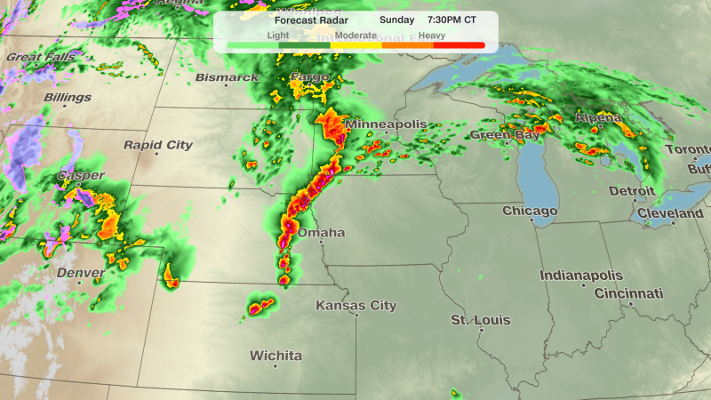
The weather system has already begun to take shape on Sunday, with rapidly intensifying thunderstorms emerging in the afternoon across Nebraska and southeastern South Dakota. These storms are bringing substantial hail and tornadoes to the region. A level 3 out of 5 risk for severe thunderstorms has been extended over much of the heartland, indicating a growing likelihood of dangerous conditions.
Weather officials have issued four tornado watches for over 3 million people in central and eastern Nebraska, southeast South Dakota, much of Kansas, and parts of Iowa and Minnesota. This includes major cities such as Omaha and Lincoln, Nebraska, as well as Sioux City, Iowa. The National Weather Service confirmed a tornado north of Grand Island, Nebraska, which struck the central part of the state. Additionally, a tornado emergency — the highest level of alert — was issued for a storm near Hebron, Nebraska, around 6:30 p.m. CT.
“A tornado emergency is only issued when forecasters are certain a large, damaging tornado is imminent,” stated the National Weather Service.
As the day progresses, the storms are expected to organize into a line, increasing the threat of damaging winds that could exceed 80 mph. This development underscores the dynamic nature of the weather system, which has evolved quickly and is now more intense than earlier forecasts suggested.
Monday’s Enhanced Risk
Monday is set to bring a widespread outbreak of severe thunderstorms, driven by a powerful surge of jet stream energy colliding with ample moisture over the Plains. The Storm Prediction Center has raised the risk level to a rare Level 4 out of 5, highlighting the potential for strong tornadoes and severe weather in parts of eastern Kansas and Nebraska.
Supercells, which are towering thunderstorms capable of producing tornadoes, are expected to form in the afternoon. These supercells may generate tornadoes rated EF2 or stronger, along with very large hail. The area under the highest risk for tornadoes spans from central and eastern Kansas into southeastern Nebraska and northwestern Missouri.
By late evening, the primary concern will shift toward widespread damaging winds, although a few tornadoes could still occur during the overnight hours. The exact impact of morning storms and their cloud cover on afternoon conditions remains uncertain, as lingering storms from Sunday night may reduce energy levels for the subsequent outbreaks.
Tuesday’s Transition and Fire Risk
By Tuesday, the storm activity is expected to ease, with ongoing thunderstorms likely to persist in the morning. The risk of severe thunderstorms will drop to a Level 2 out of 5, covering areas from northern Texas to Michigan. While the likelihood of tornadoes will diminish, wind and hail remain key threats as the cold front becomes the dominant factor in triggering storm development.
Concurrently, the same weather system responsible for the intense tornado threat has contributed to elevated fire risks in the Southern High Plains. A Level 3 out of 3 threat for fires is active from Sunday to Monday, with the highest danger concentrated in areas from southwestern Kansas to the Texas Panhandle and northeastern New Mexico. A Level 2 out of 3 critical threat spans a broader region, including much of New Mexico.
The combination of dry fuels, sustained winds of 25 to 30 mph, and gusts reaching up to 50 mph, paired with relative humidity below 10%, will create conditions where any ignited fires can spread rapidly. The National Weather Service warns that these factors could lead to life-threatening wildfires in the region.
Despite the shift in storm patterns, the Central US will continue to face significant weather challenges. The unpredictable nature of the system means that while tornado threats are expected to decrease by Tuesday, the potential for damaging winds and hail remains high. This transition highlights the complex interplay between atmospheric forces, with the jet stream playing a pivotal role in shaping the storm’s trajectory and intensity.
As the week unfolds, the focus of the weather system will move eastward, potentially affecting different regions. However, the lingering effects of Sunday’s and Monday’s storms will ensure that the Central Plains and Midwest remain under watch for severe weather. With the potential for both tornadoes and wildfires, residents in the affected areas are advised to stay informed and prepared for any developments.
